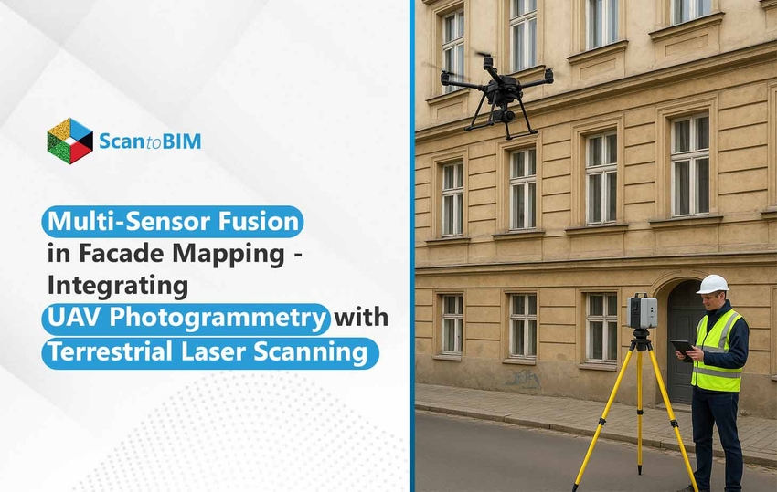
Overcoming the Challenges of Facade Documentation
Documenting the geometry of complex, tall, or inaccessible building facades has been a complicated problem for architecture firms for a long time. The conventional methods of facade documentation have numerous limitations that compromise timeline, costs, and ultimately deliverables.
- Obstructions from adjacent structures or vegetation.
- Perspective distortion when photographing from the ground.
- Unsafe work conditions when using scaffolding, rope access, or simply manually inspecting the facade.
In response to the limitations of the conventional techniques, two leading-edge technologies are revolutionizing facade documentation methods:
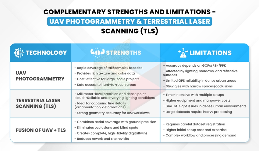
- UAV Photogrammetry – It allows for data to be captured quickly, get into things that are not typically easily accessible, and amass high-resolution texture information from above.
- Terrestrial Laser Scanning (TLS) – It generates high-density point clouds that are millimetre-accurate, measuring from the ground and creates superb geometric precision.
Each of the technologies alone is extremely useful, but combining them together creates a workflow that brings a complete, accurate, and information-rich digital twin of the documented facade. This new integrated approach allows large architectural practices to plan renovations more effectively, reduce risks, and present high-fidelity documents at scale.
Understanding the Technologies - UAV Photogrammetry & Terrestrial Laser Scanning (TLS)
Before engaging in the integration of datasets, it is important to understand the technologies involved. UAV (Unmanned Aerial Vehicle) Photogrammetry and Terrestrial Laser Scanning (TLS) engage in facade documentation, one from the air and the other from the ground, respectively, with each having its advantages and limitations, but both also provide a beneficial balance for digitally documenting the facades.
UAV Photogrammetry Fundamentals
Aerial photogrammetry operates by taking overlapping photographs using UAV cameras and producing point clouds using algorithms including Structure from Motion (SfM) and Multi-View Stereo (MVS). Accuracy is improved with the addition of Ground Control Points (GCPs) or RTK/PPK positioning technology. For an architectural firm, UAV photogrammetry converts two-dimensional images into a measurable three-dimension dataset of a facade.
Benefits of using UAV Photogrammetry to capture facades
- Provides access to taller or obscured facades without the need for scaffolding or to use a mechanically assisted lift.
- Provides rapid deployment and minimizes downtime on site.
- Eliminates the risk associated with manual climbs and other safety risks associated with the documentation of a facade.
Terrestrial Laser Scanning (TLS) Basics
LiDAR (Light Detection and Ranging) makes accurate spatial data by shooting laser pulses, measuring how long it takes for the laser to return after hitting a surface. LiDAR produces dense point clouds in the millimeter precision range. The time-of-flight enables a 3-dimensional representation of real-world geometries. LiDAR is particularly useful for conducting facade documentation as it excels in capturing architectural details like ornamentation, window frames, and surface deflections that may be less discernible using image-based documentation methods. Providing a high level of high-fidelity architectural survey, LiDAR can provide quantitative information unobtainable by image-based documentation.
Scanner Types and Performance Characteristics
| Scanner Type | Key Characteristics | Best Use Case |
|---|---|---|
| Time-of-Flight (TOF) | Long-range capability, slightly slower data capture | High-rise facades and large structures |
| Phase-Shift | Very fast capture, high density at short distances | Detailed close-range facade scanning |
| Hybrid | Combines speed with extended range | Versatile projects requiring both detail and coverage |
Setting up scan stations
- Make sure to have several stations set up around the facade to eliminate lines of sight and occlusions
- The scanning pattern must be spherical or grid-based to ensure even coverage
- Ideally placed target spheres or checkerboards for registration
Considering range, accuracy, and resolution
- Accuracy range is ± 2 mm - ± 6 mm, depending on the scanner.
- Higher resolution will provide good geometry but increases file size and processing time.
- Station planning with good spacing will produce complete coverage with little shadow zones.
Workflow of Multi-Sensor Fusion for Facade Documentation
A predictable multi-sensor-fusion workflow requires planning and execution to maintain accuracy and efficiency when modeling tall or more complex facades. While this organized system may only be applicable to the largest architectural offices, establishing a workflow like this will reduce data voids, time-consuming and costly rework, and allow for easy importing into BIM or renovation workflows.
1. Data Acquisition Planning
- UAV flights are planned to follow an optimized trajectory to capture vertical surfaces with significant overlap (70–85%), and both UAV and TLS are used to ensure adequate texture mapping and coverage.
- The TLS stations are planned at the ground level, optimally locating them to minimize occlusions or obstruction, and allowing detailed capture of the facade's features, such as ornamentation or profile details of window frames.
- Using aerial and ground perspectives to document the same facade allows for sufficient coverage and spatial accuracy of the surrounding contextual features.
2. Pre-Processing and Registration
- Images collected from the UAV are processed and transformed into a dense point cloud using photogrammetry software.
- TLS data is cleaned for noise and unwanted or unneeded data and segmented.
- Initial dataset alignment can be achieved via reference and targets that are placed on-site.
3. Alignment Methods
- The use of Ground Control Points (GCPs) provides absolute georeferencing for UAV data.
- Iterative Closest Point (ICP) algorithms allow for a final procedural adjustment of both datasets to ensure the UAV point clouds and TLS datasets align perfectly.
4. Creating an Integrated Model
- At this final step, the dataset will produce one integrated point cloud or mesh.
- The merged point cloud or mesh will provide a comprehensive digital twin of the facade that allows for accurate measurement, clash detection, and BIM integration.
Advanced Processing Techniques for Multi-Sensor Facade Data
When UAV and TLS datasets have been fused, processed technologies will transform raw point clouds into relevant models that work with the architectural firms to design, renovate, restore, and manage their buildings.
Automated Feature Extraction
- Window and Door Detection - Algorithms rapidly find repeating elements along the facade to give the operator back time creating manual models.
- Architectural Element Detection - Algorithms learn to distinguish between items flagged as cornices, balconies, and ornamentations to minimize the labor required for as-built drawings.
- Damage and Deterioration Identification - Algorithms can identify current cracks, surface erosion, or misalignment that will be relevant to restoration efforts.
- Materials Identification - Multi-modal data signifies identifying glass, concrete, stone, and brick that continues to enhance and inform documentation.
Mesh Generation and Optimization
- Triangulation Algorithms create closed and watertight meshes from point clouds.
- Level of Detail (LOD) Management optimizes resolution and processing capability, which is necessary for large projects.
- Texture Atlas Creation optimizes facade visualizations that create realistic 3D models.
Semantic Segmentation and BIM Integration
- BIM Workflows directly integrate processed facade models into design environments.
- Semantic Enrichment tags model elements with metadata (materials, condition, dimensions).
- As-Built Documentation guarantees accurate records for compliance, renovation, and facility management.
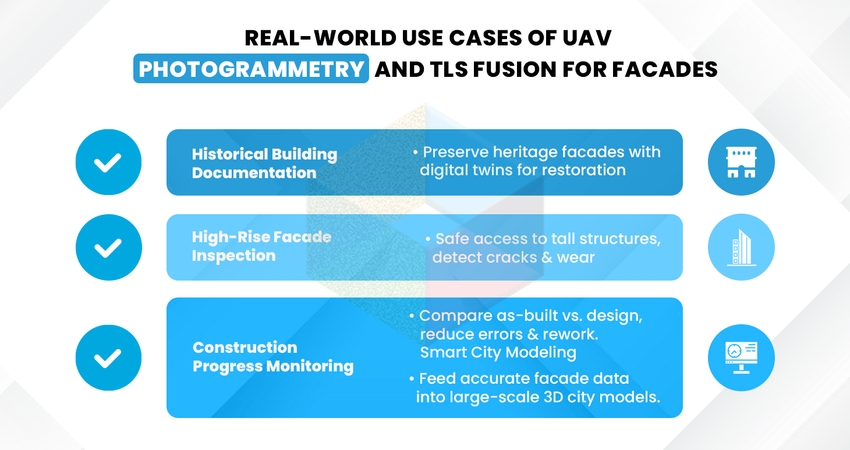
Key Advantages of UAV and TLS Fusion for Facade Documentation
For major architectural firms, the integration of UAV photogrammetry and Terrestrial Laser Scanning (TLS) offers more than just data collection. It streamlines processes to address issues related to precision, efficiency, and the ability to manage larger projects.
Elevated Precision with Holistic Coverage
- While TLS offers millimeter accuracy from the ground, UAVs photograph out-of-reach and high facades.
- The combined data removes gaps and assures full, dependable coverage of all facade geometry.
Advanced Digital Twin Visualization
- The integration results in 3D digital twins that are not only highly detailed but also feature realistic textures and precise geometry.
- Such models are invaluable for design evaluations, stakeholder discussions, and future refurbishment strategizing.
Minimized Rework and Fewer Site Visits
- Integrated data reduces the shortcomings that typically result in additional survey missions.
- Drastically cutting down requests for information and last-minute visits helps firms save both time and money.
Assists BIM Integration and Heritage Conservation
- Allows for BIM platform integration to perform clash detection, compliance verification, and asset lifecycle management.
- Essential for heritage projects that demand comprehensive documentation without physical disturbance.
Conclusion: The Future of Facade Documentation with Multi-Sensor Fusion
Using multi-sensor fusion from UAV Photogrammetry and TLS gives architectural firms a new workflow that blends the benefits of the two technologies. Benefits of UAV Photogrammetry and TLS:
- Accuracy and Accessibility: Drones always provide complete access to the facade and TLS can add precision down to the millimetres.
- Essential for Complexity: For projects with dual inspections, like a high-rise building inspection or for heritage buildings and bridges, fused workflows provide a reliable dataset, reduce errors, and focus on far fewer re-work issues.
- Future-Proof Approach: Through the facilitation of 3D digital twins and hassle-free BIM integration, multi-sensor fusion facilitates the changing requirements of AEC, heritage, and infrastructure sectors.
For firms that desire to take their facade documentation and information from a scan and make it actionable with deliverables (BIM), the next logical step is to implement a Scan to BIM workflow. scantoBIM.Online is capable of converting divergent point cloud data into intelligent 3D Modeling Services, while allowing the team to take advantage of benefits of accuracy, efficiency and scalability.
Start building accurate digital twins of your facades today using your newly acquired Scan to BIM workflow.


