

Scan to BIM is the process of 3D laser scanning a physical space to create an accurate digital representation of existing site conditions. The scanned data is utilized for designing, analyzing, and evaluating purposes, ensuring precision and efficiency in project execution. AEC professionals rely on this technology for tasks related to retrofitting, renovation, conservation, and reconstruction of buildings. The Point Cloud to BIM modeling process follows a structured workflow to develop a precise as-built representation of the site.
A 3D laser scanner captures existing site conditions in the form of data points known as points. The aggregation of millions of such points forms a Point Cloud Scan, which is then imported into a 3D BIM modeling services platform to generate a detailed as-built model of the structure.
The process of Point cloud to BIM services in the USA supports various Architectural Scan to BIM Services and engineering functions, including site verification, design validation, comparative analysis, as-built documentation, interference checks, quantity take-offs, budget estimation, and construction planning.
The documentation process includes essential deliverables such as:
- Floor Plans
- Exterior Elevation & Roof Plans
- Sections
- Site Plan Layouts
With Scan to BIM, professionals gain access to high-precision digital models that enhance collaboration, reduce errors, and streamline project workflows.
What is Point Cloud to BIM?
Point Cloud to BIM Modeling Services is a revolutionary process that bridges the gap between real-world site conditions and digital modeling, enabling architects, engineers, and construction professionals to work with high-precision representations of existing structures. This technique is essential for retrofits, renovations, historic preservation, and complex construction planning, ensuring accuracy at every stage of a project.
A Point Cloud is a dense collection of 3D data points captured through laser scanning technology. These points map the physical dimensions of a space, forming an intricate cloud of coordinate data that precisely reflects the structure’s geometry and details. Point Clouds serve as the foundation for creating detailed, data-rich Building Information Models.
Process Overview: Point Cloud to BIM Services in the USA
The step-by-step execution of a Scan to BIM process unfolds across four distinct stages, ensuring accuracy and efficiency in alignment with the BIM execution plan and project workflow.
Capture
This phase focuses on collecting comprehensive site data from both field observations and client input. It establishes the scope of work, level of detail, timeline, and project deadline, ensuring clear expectations.
A well-defined scope of work outlines all inclusions and exclusions across various trades.
Documentation takes place in two key phases:
Pre-mobilization considerations
Before site work begins, scanner selection is thoroughly evaluated. Each laser scanner offers unique advantages and drawbacks, making a cost-benefit analysis essential for choosing the most suitable device for project requirements. A site work plan is developed to streamline execution.
On-site information
A meticulous site evaluation finalizes the scope of work before project commencement. To maintain consistency and precision, a standardized worksheet template helps document critical site conditions. The expertise of the project team must align with the site’s specific requirements.
During scanning, the device is strategically positioned on a tripod for high-speed, precise data capture. The scanner emits an eye-safe rotating laser beam, which records surface positions as coordinates, collectively known as Points.
Process
Following the documentation of as-built site conditions, the next step is processing the scan. This includes validating survey data for accuracy.
Environmental vibrations may impact the fluidity of scanned data, and these disturbances might not be captured by internal system checks.
To refine the dataset, the following best practices are implemented:
- Dividing large datasets into smaller clusters for better manageability
- Creating backup copies before performing any modifications
Data Registration and Alignment
To ensure seamless integration, scanned data undergoes registration and alignment using various techniques, including:
- Best-fit adjustments
- Ortho alignment
- Geo-referencing
A manual review eliminates errors and prevents overlapping inconsistencies. Proper registration and loading of the Point Cloud Scan in the initial stages ensures a robust foundation, preventing complex correction challenges later in the workflow.

BIM Modeling
BIM Modeling is the stage where all scanned data and documentation are transformed into a precise digital representation of the project. Several structured steps ensure seamless Scan to BIM Services execution, converting Point Cloud scans into intelligent 3D models.
Verification
Before modeling begins, the scope of work, such as included and excluded trades, Level of Development (LOD) requirements, and project-specific details, must be clearly defined and communicated.
An essential step in this phase is verifying point cloud coordinates to ensure data accuracy. Widely used software solutions such as Building Scan to BIM, PointSense, EdgeWise, and Leica CloudWorx aid in this verification process.
Insertion
Once the verification process is complete, the Point Cloud scan is inserted into Revit for modeling. If multiple Point Cloud files are involved, it is crucial to verify coordinate integrity across all files before integration.
After the scan is inserted into Revit, the Pin tool is used to secure its position, ensuring consistent alignment throughout the modeling workflow.
File Set-Up
Revit file setup involves creating worksets tailored to project needs. Each Point Cloud dataset should be assigned distinct worksets to configure VVGG settings properly.
Key levels, such as Level 0 (origin point), building levels, and plan views, are established from a locked section view, maintaining structural accuracy.
Modeling
The BIM execution plan provides modeling guidelines to ensure precision and compliance with industry standards.
- Every element should be modeled as a single accurate Revit component, avoiding generic extrusions.
- Instead of using generic models with multiple extrusions, a group of correctly placed columns should be utilized.
- Walls should be refined to align precisely with Point Cloud data, ensuring clarity in plan and section views.
Collaboration
Seamless data-sharing is essential for successful Point Cloud to BIM modeling. All relevant project files should be accessible to the team, enabling efficient collaboration.
A dedicated storage system ensures smooth workflow execution, allowing team members to reference and modify files as needed.
Quality Assurance
Maintaining model integrity is a crucial step in the Point Cloud to BIM process. Several quality control (QC) steps must be followed post-modeling:
- Section Analysis: A quick model scan using visibility overrides ensures accuracy across different project elements.
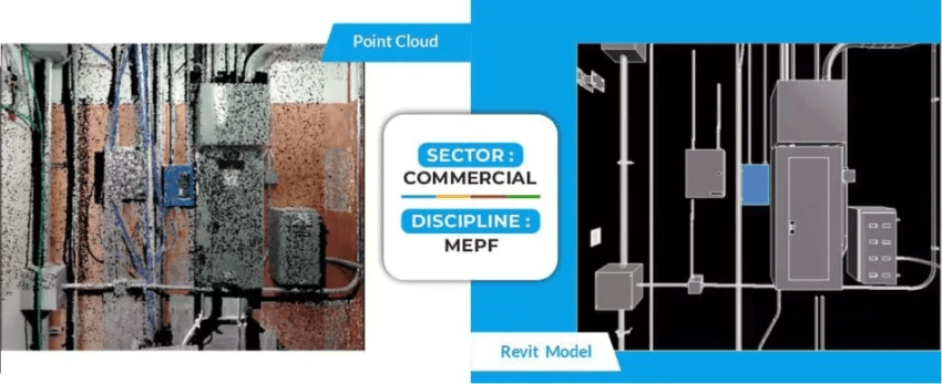
- Clash Detection: Autodesk’s Navisworks plays a key role in identifying clashes between Mechanical, Plumbing, and Electrical (MEP) systems, streamlining adjustments.
- Model Cleaning: To prevent unnecessary clutter, reference points and detailed lines should be removed from the final model.
Conclusion
Point Cloud to BIM Services in the USA offers a transformative approach to digitally representing real-world building conditions with unparalleled precision. By leveraging advanced laser scanning technology, professionals can capture highly accurate 3D site scans, ensuring every physical and functional characteristic is accounted for.
This scanned data is then seamlessly transferred to BIM software, where it undergoes a structured process to develop as-built models, enhancing project efficiency, accuracy, and collaboration. Through the four key stages outlined earlier, Scan to BIM services empower the AEC industry to streamline renovations, retrofits, and historical preservation efforts, setting new standards for data-driven decision-making and sustainable construction.
