


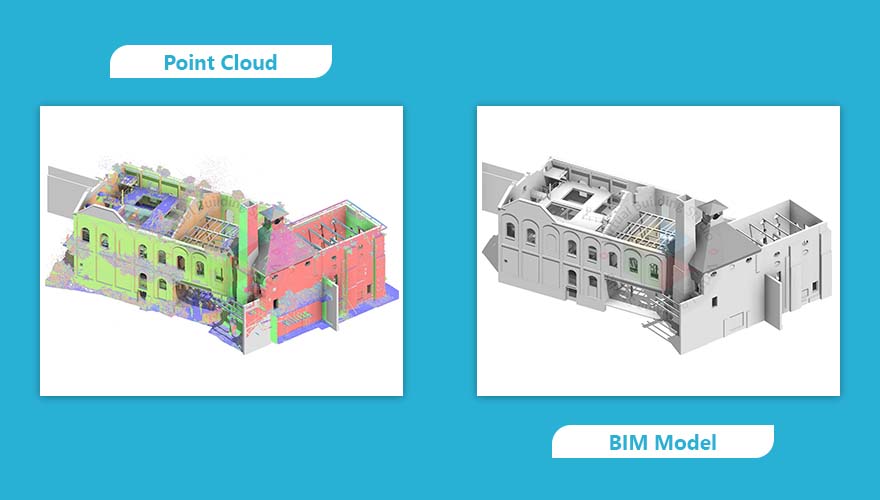
Scan to BIM services have transformed the way the construction industry captures, documents, and plans renovations and facility management with precision and efficiency. The process involves transforming point cloud data generated through LiDAR 3D laser scanning into intelligent, information-rich BIM models.
These models serve as accurate digital replicas of existing buildings or infrastructure, enabling architects, engineers, and contractors to work with precise, as-built data. For companies that focus exclusively on processing point clouds received from clients, leveraging the right tools to deliver high-quality 3D laser scan to BIM outputs is essential.
In 2025, the AEC industry continues to advance toward digital transformation, where efficiency, accuracy, and collaboration are paramount. As project demands grow more complex, choosing the right software for Scan to BIM Services becomes a strategic advantage. It allows teams to model faster, reduce manual effort, and maintain data integrity throughout the BIM lifecycle.
The increasing reliance on digital twins, demand for precise as-built modeling, and the surge in renovation planning have all contributed to the rising importance of 3D Laser Scan to BIM workflows. Whether for retrofitting aging infrastructure, upgrading MEP systems, or managing facilities post-construction, using the best-fit software is key to delivering results that are both technically accurate and commercially valuable.
Benefits of Using Point Cloud to BIM Software
In the rapidly evolving AEC industry, Point Cloud to BIM Modeling software has become a critical tool for transforming reality capture data into accurate, data-rich 3D models. For professionals delivering Scan to BIM services, this technology streamlines the process of documenting existing conditions and converting them into usable BIM outputs.
Here are some key benefits of using Point Cloud to BIM software:
- High Accuracy : Converts complex point cloud data into precise 3D models, minimizing errors and rework.
- Time Efficiency : Automated features accelerate modeling, reducing manual input and boosting productivity.
- Improved Collaboration : Seamless integration with BIM tools enables real-time updates and coordination across disciplines.
- Enhanced Visualization : Offers detailed representations of site conditions to support design and decision-making.
- Supports Complex Projects : Ideal for detailed MEP modeling, retrofits, and conservation projects.
- Cloud & BIM Integration : Ensures scalable workflows through tools like Revit, Navisworks, and cloud platforms.
- Digital Twin & Asset Management : Enables lifecycle tracking and operational efficiency post-construction.
- Future-Ready Processes : Aligns with industry trends toward digitization, sustainability, and data-driven workflows.
By adopting 3D Laser Scan to BIM tools, AEC firms can improve outcomes, reduce risks, and stay competitive in 2025 and beyond.
Best 5 Point Cloud to BIM Software for 2025
Choosing the right tools is crucial to delivering accurate, efficient, and scalable best Scan to BIM Services in USA. Here are five of the best software solutions in 2025, tailored for professionals working with point cloud data to produce high-quality BIM models:
Autodesk ReCap Pro
Autodesk ReCap Pro is a powerful reality capture tool used to convert laser scans and drone imagery into accurate 3D point clouds. Widely adopted by architects, engineers, and construction professionals, it serves as the first step in the 3D Laser Scan to BIM process.
Key Features- Advanced Point Cloud Processing : Clean, register, and optimize massive scan datasets with tools for noise reduction, outlier removal, and scan alignment, ensuring high accuracy from the start.
- Seamless BIM Integration : Directly connect with Autodesk Revit and other BIM platforms to streamline the transition from raw scan data to intelligent 3D models.
- Multi-Source Data Support : Handle data from terrestrial laser scanners, aerial photogrammetry, drones, and LiDAR, making it versatile for any capture method.
- Precision Analysis Tools : Use built-in tools for measurement, annotation, slicing, and sectioning to extract detailed insights from your scans.
- Cloud Collaboration : Share projects securely with stakeholders via Autodesk Docs, enabling real-time feedback and remote coordination.
- Automated Geo-Referencing : Align scans to real-world coordinates with minimal manual input, ideal for large infrastructure and site-wide modeling.
- Large-scale construction projects
- Urban infrastructure planning
- Pre-construction site analysis
- Location : USA
- Type of Building : Heritage
- LOD : 300
- Discipline : Architecture Model
- Software : Revit

FARO As-Built for Revit
FARO As-Built for Revit is a specialized plugin that enhances Revit’s capabilities by enabling direct modeling from point clouds. It’s one of the most favourable tools for professionals delivering scan to BIM services, especially in complex environments.
Key Features- Automated Element Extraction : Quickly extract walls, pipes, structural columns, beams, and other architectural or MEP elements directly from point clouds with minimal manual input.
- Precise Point Cloud Alignment : Align scan data accurately with existing Revit models using intuitive tools for registration, geo-referencing, and model fitting.
- Clash Detection & QA Tools : Identify design conflicts early with built-in clash detection, deviation analysis, and quality assurance features to ensure model accuracy.
- Multi-Scan Compatibility : Supports both terrestrial laser scanners and mobile scanning systems, making it flexible for indoor, outdoor, and complex environments.
- Smart Annotation & Tagging : Add intelligent annotations, dimensions, and metadata directly to point cloud elements for better documentation and collaboration.
- Seamless Revit Integration : Native Revit plugin ensures smooth workflows, allowing users to model directly within the BIM environment without switching platforms.
- MEP modeling and coordination
- Industrial facility documentation
- Renovation and retrofit projects
Leica CloudWorx
Leica CloudWorx is a suite of plugins that allows users to work with large point clouds directly within CAD and BIM platforms such as Revit, AutoCAD, and Navisworks. It’s ideal for professionals handling 3D laser scan to BIM conversions at scale.
Key Features- High-Performance Visualization : Effortlessly handle and navigate massive point cloud datasets within familiar CAD and BIM environments like Revit, AutoCAD, and Navisworks.
- Precision Modeling Tools : Use SmartSnap and Fit Section to accurately model walls, pipes, and structural elements directly from point clouds with pinpoint accuracy.
- Seamless Data Management : Integrates seamlessly with Leica Cyclone for efficient scan organization, registration, and project lifecycle management.
- Broad Format Compatibility : Supports industry-standard formats including E57, LAS, and PTS, ensuring smooth interoperability with various scanners and software platforms.
- Custom Slicing & Clipping : Create dynamic sections and slices of point clouds to isolate areas of interest and streamline modeling workflows.
- Real-Time Clash Detection : Identify and resolve design conflicts early by overlaying point clouds with BIM models for instant visual validation.
- Heritage restoration and preservation
- Structural analysis and documentation
- Complex architectural modeling
Trimble RealWorks
Trimble RealWorks is a comprehensive point cloud processing software designed for surveyors and construction professionals. It enables detailed analysis and modeling from laser scan data, making it a strong asset for Scan to BIM Services.
Key Features- Photogrammetry & Point Cloud Fusion: Combine drone imagery, terrestrial photos, and laser scans to generate rich, high-resolution 3D models with photorealistic textures.
- Scalable Mesh Generation : Create detailed 3D meshes from massive datasets, making it ideal for modeling large infrastructure, urban environments, and terrain.
- Seamless BIM Integration : Integrates with Bentley’s OpenBuildings, MicroStation, and other design tools to support smooth transitions from reality capture to BIM.
- Web-Based Visualization & Sharing : Publish and share 3D models online for easy stakeholder access, collaboration, and remote project reviews, no heavy software required.
- Transportation and infrastructure projects
- City-scale modeling and planning
- Environmental and terrain analysis
Conclusion
Choosing the right Point Cloud to BIM software plays a vital role in delivering accurate, efficient, and future-ready models. As the demand for Scan to BIM services and 3D Laser Scan to BIM Services workflows grows, using the right tools ensures better quality, faster turnaround, and improved collaboration.
It’s important to evaluate software based on your project scale, the complexity of the point cloud data, your team’s technical skill set, and how well the tool fits into your long-term digital strategy. Whether you're modeling for renovation, infrastructure, or facility management, the right software helps you stay competitive in the modern AEC industry.


