 +1 (409) 247-5496
 +61 468 036 171
Australian construction teams face a defining shift in how architects and surveyors share project data. A single coordinated model now carries geometry, measurements, and design intent in one place. Architects gain a live reference for design decisions. Surveyors gain a direct channel to feed field data into that same reference. This article walks through the reality capture workflow and the technology behind it. It also covers the practices that keep collaboration productive on real Australian projects.
The Growing Role of BIM in Australia's Construction Industry
Building Information Modelling now sits at the centre of project delivery across commercial, residential, and infrastructure work in Australia. Government agencies request digital models for major public projects. Private developers request the same models for cost certainty and design clarity. Construction firms that invest in digital technology see the payoff show up on the balance sheet. A report found that new digital technology lifts annual revenue by 1.4% for construction companies. Profitability rises by 1% in the same report. That gain compounds across a portfolio of projects over several years.
Architects design within these models from the earliest conceptual stage. Surveyors capture the physical world and translate it into coordinates that plug directly into the same file. Structural engineers, cost planners, and facility managers draw from the identical source. The result removes duplicate data entry and closes gaps between design intent and site reality. Firms exploring Scan to BIM services in Australia find that this growing digital foundation makes the transition considerably easier.
Why Collaboration Between Architects and Surveyors Matters
Architects depend on accurate spatial data before making a single design decision. A floor plan built on outdated measurements sends the whole project in the wrong direction. Surveyors supply the ground truth that architects convert into design proposals, renovation plans, and construction documentation.
This partnership matters most on renovation and heritage work, where existing conditions carry uncertainty. A building constructed decades ago rarely matches its original drawings. Walls shift, services get rerouted, and additions appear without matching paperwork. Surveyors resolve that uncertainty through direct measurement. Architects then build design work on a foundation they can trust.
Clear collaboration also speeds up council approvals. Planning authorities look for documentation that lines up with site conditions, down to the millimetre in some council districts. A model built from verified survey data usually clears that bar on the first submission. Teams turning to architectural scan to BIM providers often see this approval advantage most clearly on renovation projects.
Challenges of Traditional Surveying and Design Workflows
Traditional workflows separate the surveyor's output from the architect's input. A surveyor delivers a set of 2D drawings. An architect then interprets those drawings and manually redraws them inside design software. Each transfer introduces the chance for error.
Manual measurement methods also carry inherent limits, and a few patterns show up on almost every traditional survey:
- Point gaps between measurements: Tape measurements and total stations grab individual points across a site, and surveyors fill the space between those points by estimating.
- Curved and irregular geometry: Curved walls and irregular ceiling heights make that estimation harder, and errors add up fast on a complex floor plan.
- Approximated drawings: Architects then work from drawings that approximate the building rather than represent it exactly.
Communication gaps compound the problem. A surveyor working weeks ahead of the design team may miss changes that occur at the site between visits. An architect working from stale drawings produces a design that clashes with actual conditions. Rework follows, and rework carries direct costs in fees, schedule, and client confidence. A dependable point cloud to BIM workflow closes most of that gap before it starts.
How BIM Models Improve Collaboration
BIM models solve the transfer problem by giving architects and surveyors one shared file format. A surveyor captures site conditions and loads that data directly into a model that architects open immediately. Interpretation disappears from the equation, and the architect works from verified geometry rather than a redrawn approximation.
Every element inside the model carries embedded data: material type, dimension, and classification. An architect selects a wall and instantly views its exact thickness, height, and material composition. A structural engineer opens the identical model and checks load paths against those same walls. Every discipline references one source, and every discipline stays aligned automatically.
Version control also improves through cloud platforms built for shared access. A team member uploads an update to the central model, and everyone else sees that version within moments. Change tracking marks the exact elements that moved, so a reviewer opens the file already knowing where to look.
The Role of Laser Scanning and Point Cloud to BIM
3D laser scanning forms the technical foundation for accurate BIM collaboration on existing buildings. A scanner captures millions of coordinate points across a site in a matter of minutes. Modern terrestrial scanners record positional accuracy around plus or minus two millimeters at close range. That accuracy gives surveyors a dataset that reflects the building faithfully.
From Point Cloud to Intelligent Geometry
Those millions of points aggregate into a point cloud. This forms a thorough spatial map of every wall, ceiling, duct, and fixture at the site. The point cloud to BIM workflow then converts raw dataset into intelligent Revit geometry. Modellers trace walls, columns, and mechanical runs directly over the scanned points. The result mirrors the building's actual condition rather than a generalised approximation.
A Dependable Starting Point for Design
An existing conditions survey built this way gives architects a dependable starting point for renovation work. Instead of guessing at hidden dimensions, architects reference exact coordinates pulled straight from the physical building. Design decisions follow real data, and approval submissions carry documentation that matches reality.
BIM Workflow for Australian Projects
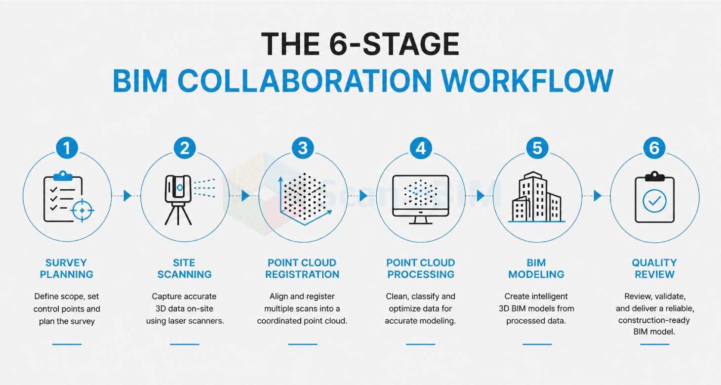
A typical Australian BIM collaboration moves through six connected stages, each feeding the next.
- Survey planning starts the process. Surveyors review existing drawings and plan scanner positions across the entire site. Surveyors account for corridors, plant rooms, and obstructed areas in advance.
- Site scanning captures every accessible space. Crews position the scanner at each station and record geometry station by station. A mid-sized commercial floor often finishes within a single day.
- Point cloud registration stitches every station into one continuous dataset using shared reference targets. A tight control network keeps registration errors within acceptable bounds across buildings with several levels.
- Point cloud processing removes noise and applies colour layers pulled from onboard cameras. This prepares a clean reference layer for modelling software.
- BIM modelling builds intelligent geometry over that reference layer. Modellers trace walls, structure, and building services to the agreed level of development. This produces the working file the design team uses going forward.
- Quality review puts the finished model side by side with the original point cloud. Any geometry drifting past the agreed tolerance gets pulled back in line before the file goes out the door.
Most Australian renovation projects settle on a level of development of 300. That benchmark gives design documentation and trade coordination enough detail to work from. Projects carrying heavy mechanical and electrical scope often push further. They step up to Level of Development 400 to support fabrication planning ahead of time.
Best Practices for Successful BIM Collaboration
Successful collaboration between architects and surveyors follows a handful of consistent practices across Australian projects.
- Agree on scope before work starts: Locking the level of development and file format prevents costly rework later.
- Share existing documentation early: Even partial drawings help surveyors plan station positions. Architects also use those records to cross-check the finished model.
- Confirm the coordinate system upfront: Projects spanning multiple disciplines depend on every file referencing an identical origin point and orientation.
- Put model reviews on the calendar: Weekly coordination sessions catch clashes and data gaps before they reach construction documentation.
- Assign clear ownership of the model: A single coordinator manages version control. This keeps every discipline working from the current file, and it prevents the confusion that parallel copies create.
Shared models tend to pay off in ways that are reflected in the numbers. A 2025 study in Frontiers in Built Environment found that BIM coordination workflows reduced design-related change orders by 80%. The authors attribute this figure to earlier clash identification during the design phase. That reduction translates directly into fewer disputes, fewer delays, and calmer construction sites for Australian project teams.
Why Scan to BIM Services Matter
Scan to BIM services give Australian architects and surveyors a proven path from raw site capture to finished design. A specialist provider handles the technical stages of registration and modeling. This frees architects to concentrate on design decisions. It also frees surveyors to concentrate on capture accuracy.
Delivery Timelines Australian Teams Can Plan Around
Scan to BIM services in Australia generally deliver a registered point cloud within two to four weeks for a scoped project. A finished Revit model and supporting 2D drawings round out the package. That timeline gives project teams a dependable planning horizon. Design work then starts on a fixed schedule rather than an open-ended estimate.
Supporting Renovation and Heritage Work
Architectural Scan to BIM work specifically supports renovation, adaptive reuse, and heritage conservation projects. These project types carry the most uncertainty around existing conditions. Architects working from a verified scan avoid the guesswork that traditional as-built documentation drawings often leave behind. Surveyors deliver data that architects trust immediately, and this trust shortens the distance between site capture and finished design.
Extending Value Across the Project Portfolio
Point cloud to BIM services extend this value across the entire project portfolio. Facility managers reference the same model years after handover. Contractors coordinate mechanical and structural trades against the identical geometry the architect designed around. Every stakeholder benefits from one accurate digital record of the building.
Conclusion
Architects and surveyors across Australia now share one connected digital workflow instead of two separate processes. Laser scanning captures site conditions with genuine accuracy. Point cloud to BIM modelling turns that capture into intelligent geometry. Every discipline references geometry directly. The result gives design teams a dependable foundation. Councils receive documentation they approve quickly. Construction teams get a model that matches what stands at the site. Firms that adopt this collaborative standard position themselves well for the next generation of Australian construction industry projects. Point cloud to BIM services provide a dependable starting point that meets this standard. Accurate digital records become the expected baseline rather than the exception.