Walk onto any major infrastructure site in Australia, like a freeway upgrade, a rail corridor, or an aging port, and you'll find the same recurring issue. Field crews pull out drawings that are five, ten, sometimes twenty years old. Those drawings show the original planned state. Over the decades, pipes shift, structures get modified, and additions happen with zero documentation trail.
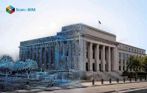
Point cloud modelling gives engineers a way out of that situation. Scanners go in, capture millions of measured points, and the actual site geometry comes back to the desk. The model reflects the current built reality, independent of the original specification intent.
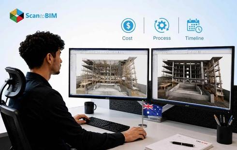
This blog explains why Australian infrastructure projects need these tools, how the workflow runs, where the real value lands, and what's coming next.
The Growing Need for Accurate Infrastructure Documentation in Australia
Australia continues to invest heavily in transport, utilities, and public infrastructure. Road widening schemes, metro expansions, and port upgrades mean the pipeline stays busy. Every one of those projects kicks off with a basic question: what's already out there?
Traditional surveying methods often produce 2D drawings that miss critical details. Structures built decades ago frequently exist with zero digital records. Project teams in these situations spend weeks verifying dimensions on site, a process that slows design progress and increases field visits.
Infrastructure documentation services now play a central role in managing this challenge. Accurate existing conditions data gives design teams a trusted spatial reference before the first drawing begins. It reduces assumptions, lowers the chance of design clashes, and gives asset owners better visibility of what they actually own.
Australia's infrastructure pipeline also includes a large volume of brownfield work. Water treatment facilities, railway corridors, airport terminals, and port wharves all of them sit in live operational environments. Getting good geometry out of those sites calls for surveying technology that works fast, covers everything, and keeps the data consistent.
How Point Cloud Modelling Supports Infrastructure Projects
Point cloud modelling uses laser scanners to capture millions of spatial measurement points across a structure or site. Each point records an exact coordinate in three-dimensional space. Each pulse bounces back with a precise X, Y, Z coordinate. Do that millions of times, and you end up with a spatial cloud that matches the real geometry of the site point for point.
Scanner teams set up at multiple positions around the structure. Each station captures what it can see. Then registration software stitches all those separate scans together into one continuous dataset. Engineers review the merged cloud for gaps before moving forward.
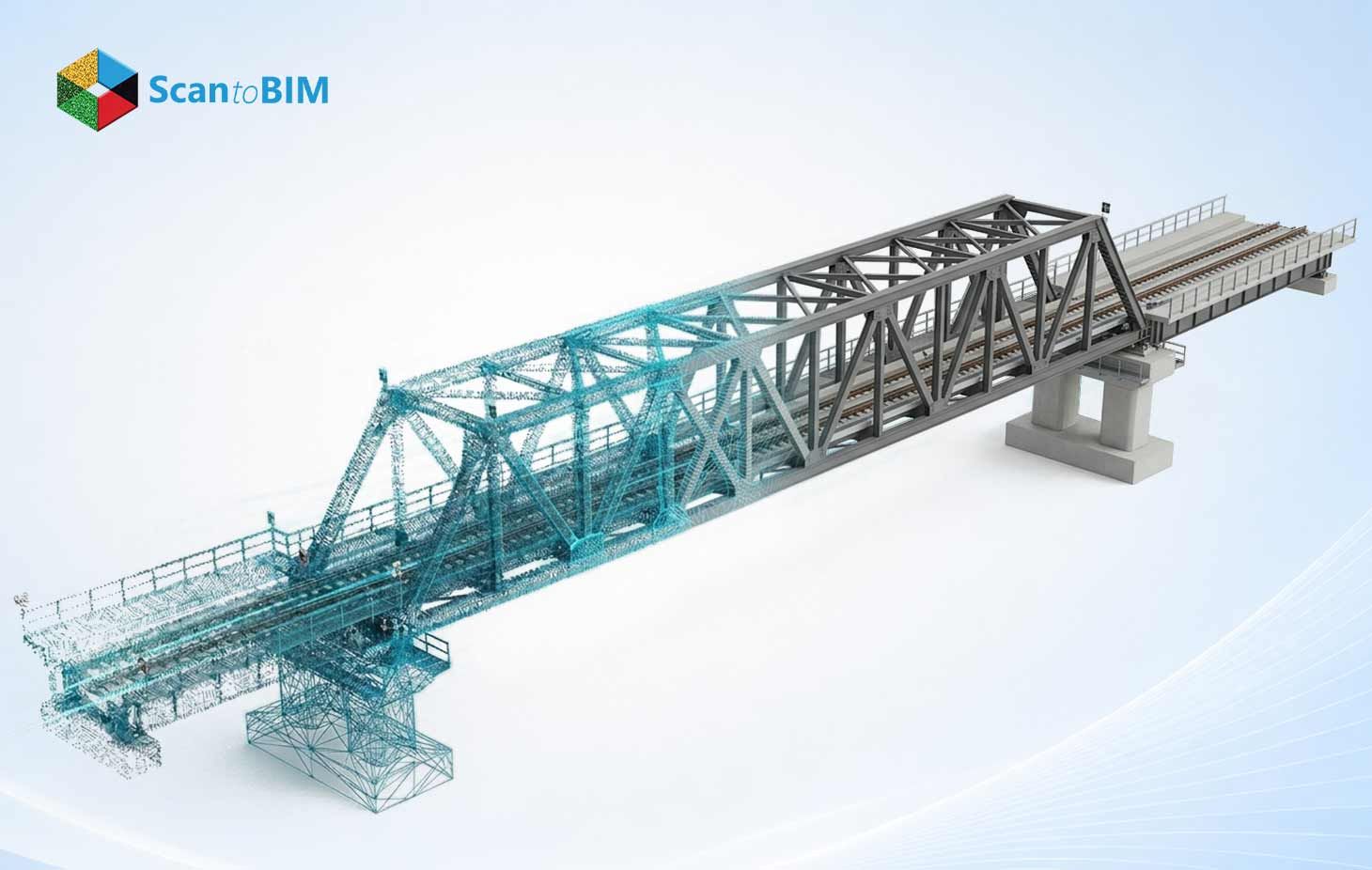
From the point cloud, BIM engineers extract geometry and build intelligent models. These models carry dimensional data, surface conditions, and element classifications that teams use throughout the full project lifecycle. Infrastructure types that commonly use this workflow, including bridges, culverts, road corridors, rail embankments, tunnels, and utility networks.
Benefits of Point Cloud Modelling for Australian Infrastructure
Teams across Australia choose point cloud workflows for several measurable reasons.
Accuracy at Scale
Laser scanning captures geometry well beyond what manual surveys achieve on large or complex sites. A study in buildings confirmed that terrestrial laser scanning hits accuracy below one centimetre under structured field conditions. On a bridge inspection or a tunnel profiling job, that level of spatial detail makes real decisions possible.
Reduced Site Visits
Engineers access the full spatial dataset from their workstations. They take measurements, review clearances, and identify clashes without returning to the site. Fewer physical visits reduce both project cost and personnel exposure in live traffic or restricted environments.
Faster Design Starts
A complete point cloud gives design teams a trusted starting reference on day one. They spend less time waiting for field surveys and more time advancing the design. Project timelines compress as a result.
Lower Rework Risk
Clash detection runs against real geometry, so conflicts show up in the model before crews reach the field. Change orders drop. Modifications that used to happen on the job are sorted at the coordination stage instead.
Coverage of Inaccessible Areas
Laser scanners reach areas where physical survey access presents safety challenges. Underbridge structures, live rail corridors, and confined spaces all fall within the operational range of modern scanning equipment. The scanner captures geometry without contact and without disrupting operations.
Point Cloud to BIM Workflows for Infrastructure Documentation
The conversion from raw point cloud data to a usable BIM model follows a structured workflow. Each stage tightens the data before the next stage begins.
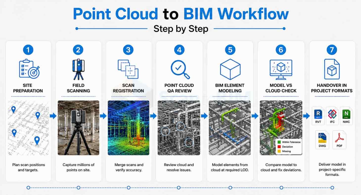
Step 1: Site Preparation
Survey crews walk the site before any scanner goes up. Access routes, scan positions, and target locations are mapped out so the field phase runs efficiently from the first setup.
Step 2: Field Scanning
Laser scanning services bring in survey-grade scanners. Each station fires millions of pulses at the surrounding environment and records every return with a precise coordinate.
Step 3: Scan Registration
All individual scan stations get merged. The software lines up shared targets and tie points across the dataset. BIM professionals confirm the deviation sits inside the project tolerance before proceeding.
Step 4: Point Cloud QA Review
The merged cloud goes through a quality pass. Noise artifacts, shadow gaps, and any misregistered zones get flagged. The team clears those issues against the project's level of accuracy spec.
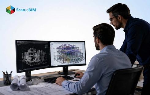
Step 5: BIM Element Modelling
Engineers trace every required element directly off the cloud. Geometry, dimensions, and classification data go into the model at the specified LOD. Nothing gets assumed from old drawings.
Step 6: Model vs Cloud Check
The finished BIM gets overlaid on the original point cloud. Any dimensional drift gets caught and corrected before the model leaves QA.
Step 7: Handover in Project Formats
The team packages the model for Revit, Civil 3D, or InfraWorks depending on the project workflow. Coordination and design work picks up from day one of receipt.
Point Cloud to BIM Australia projects run this workflow whether the scope covers a single bridge span or an entire road corridor. The depth of modelling adjusts to match the LOD spec and what the asset requirement needs downstream.
As-built BIM modelling targets what's standing on site right now, the actual built condition, including every deviation from the original design. That's the document that aging assets in Australia genuinely need.
Supporting Asset Management and Digital Twin Initiatives
Infrastructure owners across Australia now invest in digital asset management strategies. They want models that support maintenance planning, condition monitoring, and lifecycle decisions well beyond the construction phase alone.
A point cloud model feeds directly into an asset management program. Bridges, tunnels, road networks, and utility systems all get a georeferenced spatial record tied to their inspection history and maintenance schedule. Asset managers open that model and see the structure as it actually stands, with all the condition data linked to the geometry.
Scan to BIM for infrastructure workflows:
Build the model with long-term use in mind from the start. Element naming conventions, classification codes, and parameter structures all line up with the asset management platform the owner actually runs. The model works as a live spatial record, a working operational tool rather than a static archive file.
The digital twin use case also extends to structural health monitoring. Teams overlay point cloud data captured at different intervals to detect surface movement, deflection, or volume change in structures over time. This comparative analysis supports fact-grounded maintenance decisions and eliminates the need for destructive investigation.
Handover to operations teams also lands better. Operators get a model tied to real site geometry, the actual constructed asset, captured as it stands. Spatial planning, service routing, and emergency response all run off the same verified record.
Challenges and Best Practices
Every field scanning project faces practical challenges. Teams that understand these challenges plan more effectively and produce better outcomes.
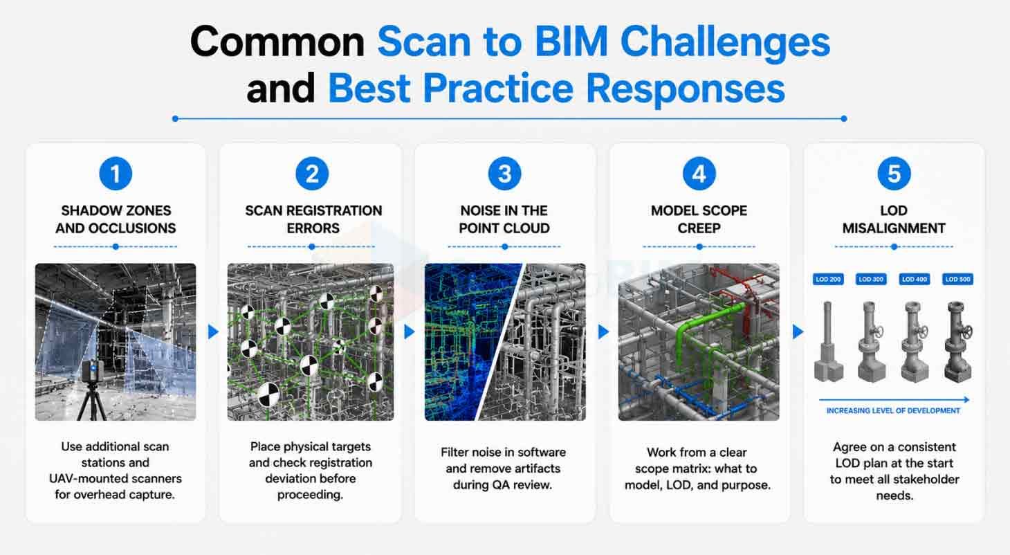
Challenge 1: Shadow Zones and Occlusions
Box culverts, bridge soffits, and tight corridor zones block scanner sightlines at standard station positions. Experienced crews add targeted stations and bring in UAV-mounted units for overhead geometry that ground scanners miss.
Challenge 2: Scan Registration Errors
Misaligned stations produce offset geometry and phantom edges in the merged cloud. Physical targets go in at the start of every setup, and the team verifies registration deviation before moving on.
Challenge 3: Noise in the Point Cloud
Traffic moving through a scan, wind-blown scrub, and surface reflections all drop unwanted returns into the dataset. Processing software handles most of it, and the QA review catches what gets through.
Challenge 4: Model Scope Creep
Infrastructure sites hold far more elements than any single project scope covers. A written scope matrix at the project start specifies exactly which elements get modelled, at what LOD, and for which downstream purpose.
Challenge 5: LOD misalignment
Stakeholders often arrive with different expectations about model detail. Getting everyone onto the same LOD plan at project start keeps modelling efforts targeted and the output useful for every team that receives it.
A laser scanning company in Australia with infrastructure experience brings tailored site protocols that address these challenges systematically. Proper planning at the scan stage prevents most downstream modelling problems.
Future Trends in Infrastructure Documentation
The tools and methods available for infrastructure documentation continue to advance quickly.
Mobile Laser Scanning
Vehicle-mounted and UAV-mounted scanners now cover long infrastructure corridors in a single pass. Road surfaces, retaining walls, overhead structures, and drainage features all appear in a single dataset captured at road speed. This dramatically reduces field time on linear infrastructure projects.
Automated Point Cloud Processing
Automated classification tools now sort point cloud returns by element type, skipping the manual labelling step entirely. Bridge deck surfaces, guardrail lines, kerb runs, and pavement markings get tagged and pulled out of the raw cloud. Engineers redirect that saved time toward model decisions and quality review.
Integration with GIS Platforms
BIM outputs now link directly into GIS environments. Asset owners see spatial data, utility records, planning overlays, and environmental datasets all in one view. That connected picture supports investment decisions and maintenance prioritisation across whole infrastructure portfolios.
Increased Adoption Across Australia
State and federal infrastructure programs increasingly call out for scan to BIM deliverables in their project briefs. Existing condition capture has moved from a nice-to-have into a standard project requirement.
Point Cloud to BIM for Existing Buildings workflows now appear across aged bridges, legacy road infrastructure, and heritage-listed transport assets as Australia's digital twin programs get funded and approved.
Conclusion
Accurate infrastructure documentation gives project teams a stable foundation for design, construction, and asset management. Without it, teams make decisions from incomplete or outdated information, and that gap creates avoidable cost and risk.
Point cloud modelling closes this gap with speed, accuracy, and spatial richness that surpasses traditional survey methods entirely. Australian infrastructure owners, engineers, and asset managers gain a trusted record of existing conditions from which every downstream decision can proceed with confidence.
The value extends well beyond construction. As-built documentation, digital twin readiness, and long-term asset management all draw from the same superior quality scan data. Teams that invest in proper documentation at the start of a project generate that value across the full asset lifecycle.