The United States government owns one of the largest building portfolios on Earth, with structures standing across every state. Federal agencies manage courthouses, military bases, laboratories, post offices, and historic landmarks that often date back many decades. Original paper or hand drawings frequently went missing or aged past usefulness as each building changed steadily across the years. Facility managers then face a challenging question about how to maintain a structure when its documents misstate the true shape.
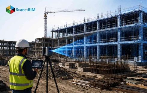
Reality capture answers that question through laser scanners that record millions of measurements across a federal facility within a few hours. Modeling teams then turn that raw data into accurate digital buildings that mirror the real space with careful detail. This workflow now anchors how federal agencies plan renovations, track their assets, and protect aging infrastructure across large portfolios.
Challenges of Managing U.S. Federal Buildings
Federal facilities carry heavy operational demands because each property serves the public, houses working staff, and follows strict construction codes. Aging systems raise the stakes year after year as equipment ages, and the original design intent fades from memory.
Outdated documentation
Most older heritage federal buildings hold records that show the original design rather than the building as it stands today. Decades of retrofits changed walls, ducts, and wiring. Professionals discover hidden surprises behind nearly every ceiling tile during work.
Strict compliance demands
Agencies follow accessibility standards, energy mandates, and security rules on every single federal project. Accurate field data supports each of these requirements, and rough guesswork creates real risk for the owner and the team.
Tight budget pressure
Public funds back federal construction and answer directly to taxpayers and watchful auditors. Each project demands a clear justification for its spend; accurate data strengthens that case and protects the public budget.
Vast portfolio scale
A single agency might oversee thousands of separate structures spread right across the entire country. Manual surveys move slowly and consume large budgets; teams across these agencies clearly need a faster path to truth.
Manual measurement error
Tape measures and laser distance meters carry their flaws that compound quickly across a large effort. A human reads each value and writes it down; errors creep into the record across many thousands of measurements.
These challenges stack together pushing renovation costs and project timelines well past the schedule the owner first approved. Federal teams need one accurate method that removes the guesswork and replaces aging records with measured truth.
Why Federal Agencies Are Adopting Scan to BIM
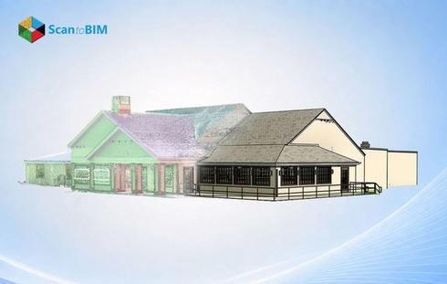
Agencies want certainty, and Scan to BIM delivers exactly that level of confidence across the full project lifecycle. The method captures real existing conditions and converts them into a working model. Decision-makers act on facts rather than assumptions. Speed drives much of the appeal because laser scanners gather a complete record of a large space within a single site visit. Modeling specialists then transform that record into a usable digital building. This pace suits the tight schedules federal projects demand.
Cost control matters just as much for federal owners who watch every public dollar throughout a project’s lifecycle. Stanford University's Center for Integrated Facilities Engineering studied 32 major projects and found that BIM produced up to a 40% reduction in unbudgeted change orders. Federal owners watch every dollar closely; fewer surprises during construction translate directly into real and measurable cost savings.
Accuracy seals the case because a finished digital model mirrors the building down to fine tolerances at every level of detail. Designers, engineers, and contractors then share one accurate single model across the whole project team and every discipline.
Common Federal Building Use Cases
Federal agencies apply this workflow across many property types, and each individual use case solves a clear operational need. Historic or heritage preservation ranks high on the list because many treasured federal landmarks carry protected legal status under the law. Scanning records every ornamental detail with great care. Preservation teams then plan repairs that honor the original craft.
Courthouses and office complexes form another large group that hosts constant renovation and fit out work year after year. Accurate models guide space planning and steady system upgrades. Teams avoid costly clashes throughout the entire construction phase.
Military and defense facilities also benefit because these bases contain complex utility networks and tightly controlled secure operating zones. Digital models map all of these systems with full clarity, so planners route new infrastructure around existing assets safely.
Laboratories and healthcare facilities round out the field with sensitive equipment and tightly packed mechanical and electrical layouts. Precise capture protects ongoing operations during any upgrade and keeps the critical building systems running throughout the active work.
Data centers form a fast growing category as agencies run large server facilities with tightly packed equipment racks. Accurate models map the cable trays, cooling systems, and power distribution. Then planners expand capacity around live operations.
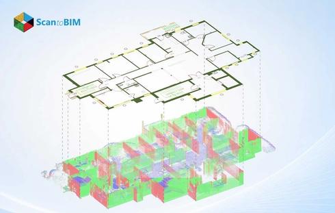
How the Point Cloud to BIM Workflow Runs
The workflow follows a clear sequence where each stage builds on the one before it. Specialists move from raw field data to a finished digital building across five connected steps.
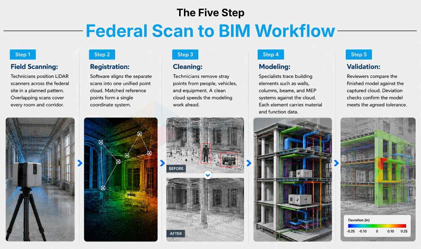
Step 1
Field Scanning: Technicians position LiDAR scanners across the federal site in a planned pattern. Overlapping scans cover every room and corridor.
Step 2
Registration: Software aligns the separate scans into one unified point cloud. Matched reference points form a single coordinate system.
Step 3
Cleaning: Technicians remove stray points from people, vehicles, and equipment. A clean cloud speeds the modeling work ahead.
Step 4
Modeling: Specialists trace building elements such as walls, columns, beams, and MEP systems against the cloud. Each element carries material and function data.
Step 5
Validation: Reviewers compare the finished model against the captured cloud. Deviation checks confirm the model meets the agreed tolerance.
These five steps turn millions of raw points into a trusted federal building model. The team then packages every deliverable for a clean project handover.
Laser Scanning Technologies Used in Federal Projects
Federal projects call for the best capture tools available, and the right hardware matches the building type and required detail. Specialists choose a tool set that fits the specific site, the project schedule, and the accuracy the agency requires.
- TLS scanner: Terrestrial laser scanners anchor most jobs as technicians place these tripod units at carefully planned stations across the site. Each scan records millions of points across the walls, floors, and ceilings, so the result forms a faithful spatial record.
- Mobile scanner: Mobile mapping systems suit larger campuses where a technician walks or drives through a space while the unit captures continuously. This approach covers vast federal sites quickly, and Reality Capture Technology of this kind shortens the fieldwork stage dramatically.
- Drone scanner: Drone photogrammetry handles rooftops and exterior facades that ground teams reach with real difficulty during a standard site survey. Modeling teams then merge this aerial data with the interior scans to build one complete picture of the whole structure.
Quality 3D laser scanning services combine all of these capture methods together to fit each project and each specific agency goal. Specialists select the precise tools that deliver the cleanest data within the project schedule and within the available working budget.
Scanner accuracy ranges from two to four millimeters on quality terrestrial units used widely for federal documentation work today. Each scan also captures color data through a built-in camera; the colored cloud helps modelers identify materials with ease.
BIM Deliverables for U.S. Federal Buildings
Federal owners expect clear, usable outputs, and the modeling process produces several distinct deliverables that serve different project teams.
The federated BIM model stands as the core deliverable that holds every design discipline in one coordinated digital environment. This single file carries the structural, architectural, and MEP elements together. Stakeholders open one model and view the building.
BIM Forum Level of development spec governs how teams build each individual element across the model for the federal owner and project. Federal projects often specify LOD 300 for design coordination, while some renovation jobs reach LOD 400 for true fabrication accuracy. The point cloud modeling team then matches the finished model to the exact requirement the agency states upfront.
Point cloud to BIM workflows also produce as-built documentation services outputs drawn straight from the coordinated digital model. These outputs include accurate floor plans, sections, and elevations. Facility managers archive these documents for any future renovation work.
Asset data forms the final piece as the model carries rich information about the equipment, materials, and installed building systems. Operations teams then pull this asset data into facility management platforms. The building becomes a living and lasting digital record.
File formats matter for the federal handover, and teams deliver native Revit files for the active and ongoing design work. They also export open IFC files for the long-term agency archives; the model stays usable across many platforms for years.
Benefits of Point Cloud to BIM for Federal Facilities
The advantages reach across the entire facility lifecycle, and each clear benefit ties back to cost, safety, and control. Federal owners gain measurable returns at every stage from early design through to daily operations.
- Better renovation planning: Teams design upgrades against real measured conditions rather than aging and unreliable drawings. Field clashes drop sharply, and Stanford CIFE research found estimates landed within 3% of figures.
- Easier compliance: Accurate models document the accessibility routes, fire systems, and required egress paths across the facility. Agencies then demonstrate compliance with hard evidence drawn straight from the model.
- Less field time: A single scanning team captures a large building in days rather than long weeks. Staff inside the facility face fewer disruptions while the capture team works around the schedule.
- Tighter trade coordination: Structural, architectural, and MEP teams work together from one shared coordinated model. Each team spots conflicts early and resolves them inside the digital space.
- Stronger asset management: A digital twin for federal facilities holds every building system inside one accessible coordinated model. Managers then track maintenance, plan repairs, and schedule replacements with real confidence.
Long-term cost savings complete the case as point cloud to BIM for federal buildings reduces guesswork at every project stage. Owners then spend less on costly surprises and far more on carefully planned improvements across the whole property portfolio.
Future of Point Cloud to BIM in Federal Infrastructure
The road ahead points toward deeper digital adoption, and federal digital infrastructure transformation continues to gather real momentum across agencies.
Automation will speed the modeling step as software now recognizes common building elements within the captured point cloud data. This capability shortens delivery times and frees specialists to focus their attention on the more complex modeling tasks. Digital twins will grow richer over time as future models link to live sensor data inside the working federal buildings. Managers will then monitor energy use, occupancy, and equipment health in real time across many separate properties at once.
Cloud collaboration will widen access as teams across the whole country open the same shared models from any location they choose. This broad reach suits the distributed nature of federal property portfolios that span many states and many separate time zones. The direction stays clear as agencies will treat accurate digital buildings as standard infrastructure for the coming decades ahead. Early adopters position their portfolios today for the data and insights that the upcoming operational years will require.
Conclusion
Federal buildings carry history, scale, and real complexity in equal measure across a portfolio that serves the whole nation. Accurate documentation forms the solid foundation for every renovation, audit, and upgrade that these federal agencies plan and fund. Point cloud to BIM gives agencies that strong foundation through fast field capture and faithful, detailed digital modeling work.
The workflow matters because it cleanly replaces rough guesswork with measured truth that the whole project team can trust. Teams then plan against real conditions, control their project costs, and protect aging assets across the full building lifecycle. Researchconfirms the genuine savings that strong design coordination delivers on real and active federal projects.
Federal infrastructure will keep moving toward digital methods as these tools grow faster and far more capable each year. Agencies that adopt these tools today position their portfolios for a clearer and more manageable operational future ahead. Accurate models serve the important public buildings that serve the nation across every state and every working agency.